


Flash Flooding Threat-July 14, 2025
Heavy rain threats the DC Region tomorrow, some will see flooding. Lots of rain in not a lot of time.

It has been very wet in the Mid-Atlantic the last few months with the region having a large surplus of rainfall. The last week or so in the DC area for the most part has been slow moving thunderstorms that are diurnally forced. They occur in the afternoon due to warm and humid environment. Synoptic rains come from frontal troughs, those are the larger complexed that we see coming the day before. Diurnally forced ones are a little harder to predict, we can forecast the likelihood of them, but harder to tell the placement of them. These storms usually are slow movers and can produce heavy rainfall in short period of time

Regarding tomorrow’s rainfall threat, do believe concern exists for more widespread flash flooding. In this article, we will look at the meteorology behind why this is, and ground conditions that led to it.
A slow moving cold front will trail behind the region with strongest rain potential. I will get to other reasons why storms will be slow moving, but the lethargic speed of the front will be one reason why these storms will be slow. Not much speed on the forcing aspect, so really nowhere to go for rain. The front acts as a nudger, and slow nudge results in slow to no storm movement. I have outlined the area of concern for heavier rainfall due warmer temperatures. The rain will be moving into a warm and moist environment with dew points above 70˚F.
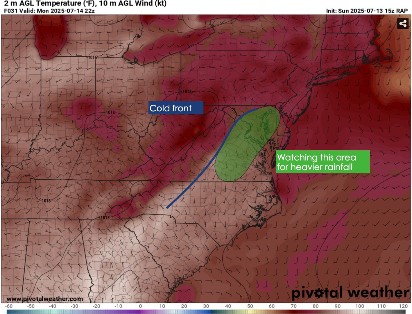

When forecasting weather, if it’s active or dry it is key to look at what’s happening above us. This shows the storm movement and speed. Also cam tell us a cold airmass and warm one. Ridges are warm, troughs are cooler. When fall comes, we will discuss that. These winds are often stronger in the winter due to surface temperature gradients.
Regarding tomorrow’s rain, we know the storms will be slow because upper level winds will be weak. The front is key, but upper level winds really determine how fast things move. At only 10 kts, storms will have a top speed of 10 mph tomorrow, which will increase flood potential due to slow storm motion causing rain to be in one spot for a long time.
Wind direction is also key, southerly winds help bring in more moisture, while northerlies are cooler and dry. Westerly winds with some southwest component are key for heavier rain because it helps carry moisture. I could see localized higher totals in the SW winds, which would be DC to Baltimore.

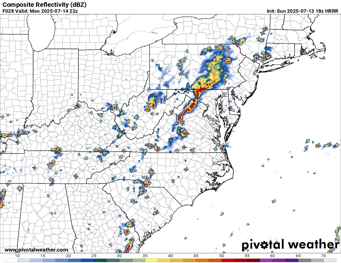
Now that the upper air has been covered, we can look at important surface features. One is cloud temperatures and depth. This projected look on satellite shows very deep convection in western Maryland and Northern Virginia. Deep warm clouds with very cold cloud tops are a good sign of strong convection. Stronger the storm, heavier rain that will follow

A very important part of forecasting heavy rain is perceptible water values (PWAT). This essentially is how much water vapor the atmosphere can hold. Values above 2.0 are generally considered tropical. Guidance agrees values will be above that, which means it will be efficient is heavy rainfall. Will be easy for higher totals. This would approach daily records for Dulles, so environment will be very much primed for heavy rain.


Looking at instability is not only important for severe storms, but flooding. More instability in place, the heaviest rain will be. Generally, >1,000 jkg is enough and there will be over 2,000 tomorrow. Plenty of fuel. There will be severe storms, but main threat will be flash flooding.

Storms are likely tomorrow evening, and could be quite heavy, for reasons above, there will be a stronger risk for flash flooding compared to recent days.
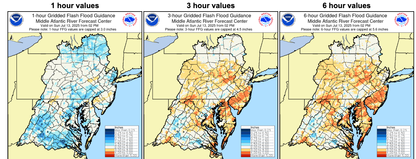
It will not take much to cause flooding which is why there is a Level 2 risk out. Less than an inch per hour will cause flash flooding, or 2 in three hours. This should not be hard to reach due to heavy rain, especially slow moving storms at 10 mph at most. I do think there is a chance for Moderate Risk for the DMV tomorrow. This is only confidence in heavy rain reaching flash flood guidance.
When forecasting, it is usually not advised to look at the highest value, because that has a 10% chance of happening. In certain situations it is smart to look. Up to three inches of rain in any spot, with some near five. Not everyone will see these totals. Some will get a half inch, while the town over has flooding. But potential is there for very heavy rain.

Looking at the environment tomorrow, it is excellent for storms and heavy rain. I will focus on the rain part. There is deep saturation, and that is visible looking at temperature (red line), dew point (blue line). Also looking at the green relative humidity box, 80* the entire atmosphere is very impressive. Shows deep convection. PWAT at 2.3 is exceptional for heavy rain, and will be very efficient at heavy rainfall. Plenty of instability with this one. Any SE moving storm will be essentially stationary, going against surface wind direction. Max movement is 10 mph. This is a very helpful website for easy analysis and reanalysis by my friend, find his account here

To summarize, heavy rainfall threat tomorrow with numerous inches of rain and there will be flooding in spots. Be safe, and turn around when encountering flooding.