May 19, 2026
Two more days of heat before thunderstorms tomorrow. Cooler end to the week with numerous rounds of showers

This blog covers the Washington DC Area. Please consider subscribing for emails in your inbox every morning and to join my live chat which will be active during active weather.
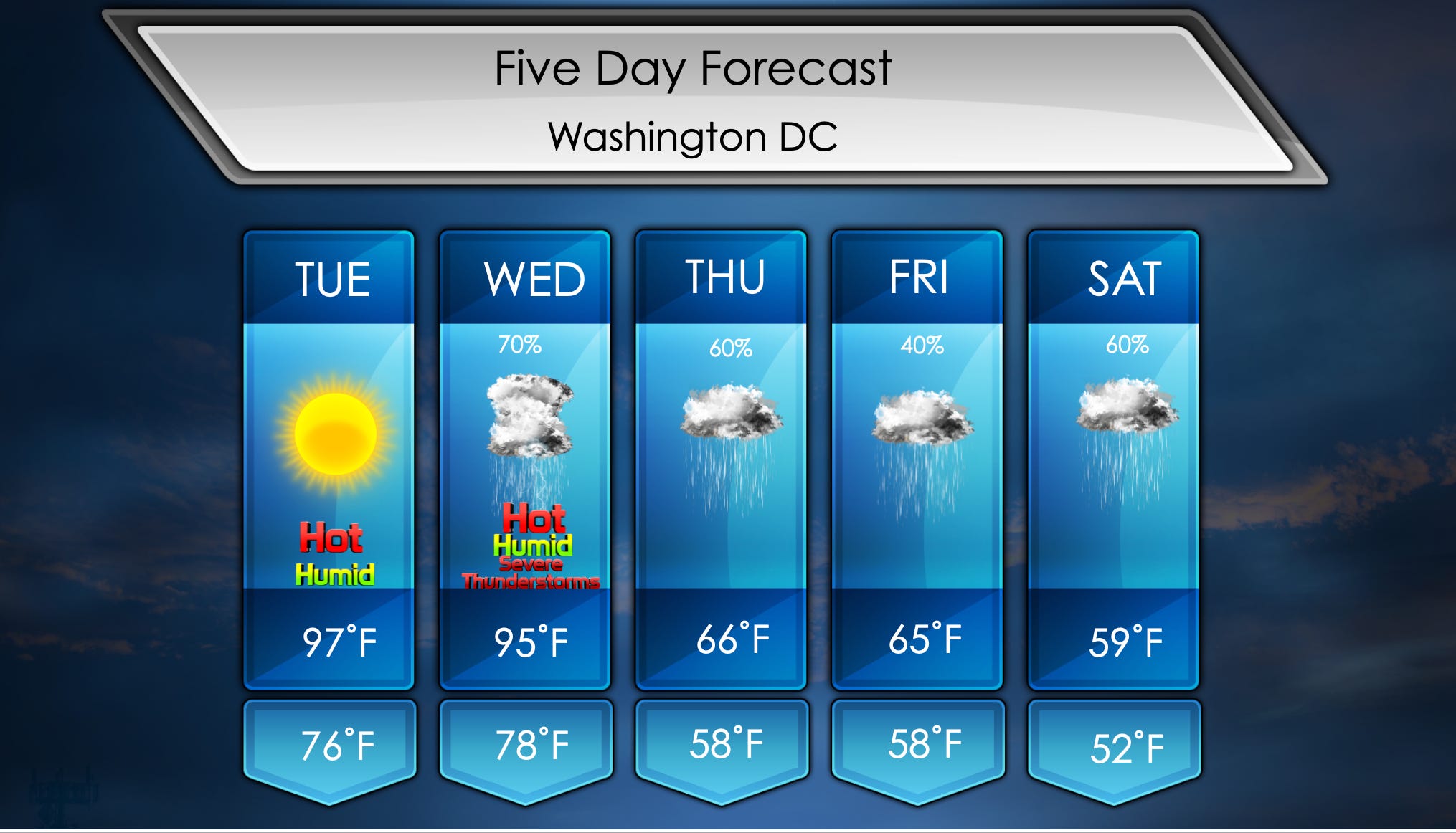
Good morning everyone! Hot yesterday with temperatures in the low 90s. Even hotter today and tomorrow with temperatures expected to be in the mid to upper 90s. This would be hot for July, but we’re talking about record heat for May. Appreciable rain is expected Wednesday and beyond with over an inch possible ending Sunday. Numerous days of rain is expected.
Hotter temperatures expected today, don’t forget to take breaks if working outside and drink plenty of water. Morning temperatures will be in the mid 70s with plenty of sun. It has been sunny the past several days, but clouds will come out for awhile beginning Wednesday evening. Afternoon highs will be in the mid to upper 90s. While humidity will be on the lower side preventing storms, it won’t matter much with the heat. We will feel it today.
Tomorrow will be hot once again, but thunderstorms will cool it down for the remainder of the week and weekend. Good chance of them, arriving after 3:00 PM ahead of a strong cold front. While it will not be too windy after the front, we will notice sharp drop in temperatures. Some storms could be severe with damaging winds and hail. Morning temperatures will be in the mid to upper 70s with plenty of sunshine. Once again humidity will not be overly high, but with hot temperatures it won’t entirely matter. We will see highs in the mid to upper 90s with thunderstorms arriving during the evening hours.
Active pattern continues Thursday after the cold front tomorrow due to shortwaves overhead. Rain will be ongoing most of the day,. but should end by sunset. Temperatures will be cooler for the next several days. Sharp shift from the week. Morning temperatures start off in the upper 50s with showers ongoing. Should continue into the afternoon with cooler temperatures in the mid 60s.
Similar day on Friday with cooler temperatures and scattered showers. Keep that umbrella on you. Morning temperatures will be in the upper 50s with showers beginning in the morning. Should see rain continue for part of the afternoon with highs in the mid 60s.
Remaining active on Saturday with low pressure bringing more rain. Monitoring where warm front sets up. Currently it is forecasted to be comfortably south of us, but if it does make its way north it would increase thunderstorm chances. Do not think it will be very warm either due to high pressure over New England shoving cold air down the Appalachians. Morning temperatures will be in the low 50s with showers possible. Really not warming up a whole lot with highs in the upper 50s.
Long Range
Better chance for thunderstorms comes Sunday as the warm front is anticipated to lift north of us. Allowing high pressure north of us to scoot east well off the coast. This will result in warmer temperatures, higher humidity and frequent thunderstorms. More details will come in coming days.