May 3, 2026
One more cool day today. Warm week ahead with thunderstorms Thursday

This blog covers the Washington DC Area. Please consider subscribing for emails in your inbox every morning and to join my live chat which will be active during active weather.
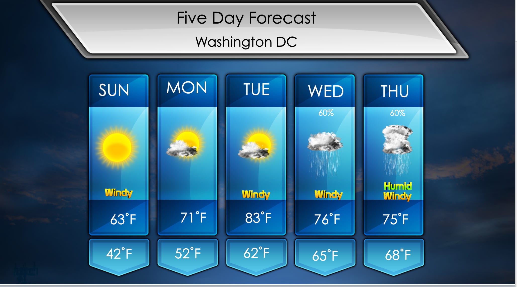
Good morning everyone! Yet another cooler day this week. Rain did end up missing well to the southeast, and we remained dry. Windy for the next three days but we will gradually be warming up until Thursday. Watching Wednesday and Thursday for two chances of rainfall. Thunderstorms are even possible Thursday.
Seasonably cool day once again is expected with spotty gusts up to 20 mph in the afternoon. Morning temperatures will be in the mid 40s with overnight lows in the low 40s. Frost is possible north of 70, so protect those plants. Skies will be sunny all day, not getting very warm in the afternoon with highs in the low 60s.
Tomorrow will be the first truly warm day in awhile with seasonable temperatures. Morning temperatures will be near 50˚F with plenty of sunshine. Due to drier air we will quickly warm up to the low to mid 60s by late morning. Warm afternoon is in the cards with highs in the low to mid 70s with some clouds filtering in.
Another warm day is in the forecast on Tuesday with gusts up to 25 mph in the evening. You will definitely notice the wind out there. Morning temperatures will be in the low 60s with plenty of sunshine. This is not a humid airmass, so we will once again quickly warm up by late morning. This time with temperatures in the low 70s. Clouds will increase in the evening with highs in the low 80s.
Rainfall is expected most of Wednesday ahead of a cold front. Still uncertain on timing and totals, but confidence is there to add it in the forecast. Morning temperatures will be in the mid 60s with showers possible during this time. Rain possible in the afternoon, but getting warm again with highs in the mid 70s.
Another warm day Thursday with chance of thunderstorms. Strong humidity is also in the forecast which will allow fuel for storms ahead of the front. Very windy day is possible with gusts up to 40 mph before the front arrives. Earlier arrival of storms would put a lid on temperatures and result in less impact. Still will be enough to watch for thunderstorms, details will come later. Morning temperatures will be in the mid to upper 60s with thunderstorms and plenty of humidity. Highs in the mid 70s.